| Del Rey silt loam, 0 to 2 percent slopes | 192A | 3175 | 1913578 | 2277b | il031 | 2008 | 1:12000 |
Del Rey silt loam, 0 to 2 percent slopes | 192A | 305 | 183364 | 64sz | il043 | 1998 | 1:12000 |
Del Rey silt loam, 0 to 2 percent slopes | 192A | 971 | 198334 | 6ncw | il053 | 2001 | 1:12000 |
Del Rey silt loam, 0 to 2 percent slopes | 192A | 7004 | 175557 | 5wp4 | il075 | 1980 | 1:15840 |
Del Rey silty clay loam, 2 to 6 percent slopes, eroded | 192B2 | 1737 | 175558 | 5wp5 | il075 | 1980 | 1:15840 |
Del Rey silt loam, 0 to 2 percent slopes | 192A | 473 | 1712534 | 1vh11 | il093 | 2007 | 1:12000 |
Del Rey silt loam, 0 to 2 percent slopes | 192A | 1730 | 634369 | p93j | il097 | 2003 | 1:12000 |
Del Rey silt loam, 2 to 4 percent slopes | 192B | 328 | 776686 | v26d | il097 | 2003 | 1:12000 |
Del Rey silt loam, 0 to 2 percent slopes | 192A | 916 | 176937 | 5y3n | il105 | 1991 | 1:15840 |
Del Rey silt loam | Dr | 1064 | 164683 | 5jcc | in003 | 1965 | 1:15840 |
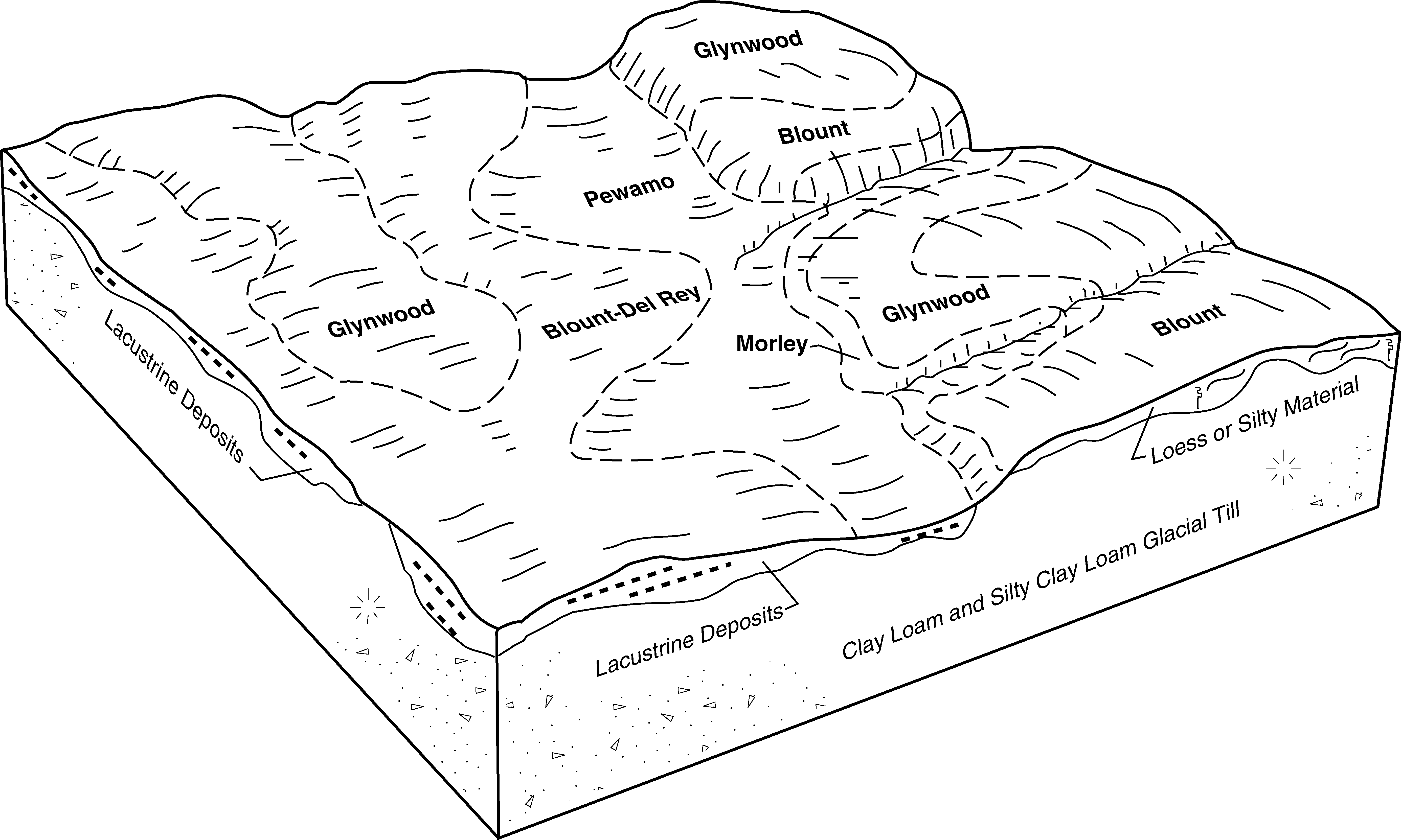
Blount-Del Rey silt loams, 0 to 1 percent slopes | BmlA | 42866 | 164784 | 5jgm | in035 | 1997 | 1:12000 |
Del Rey silty clay loam, 0 to 1 percent slopes | DcrA | 557 | 165356 | 5k22 | in039 | 1997 | 1:12000 |
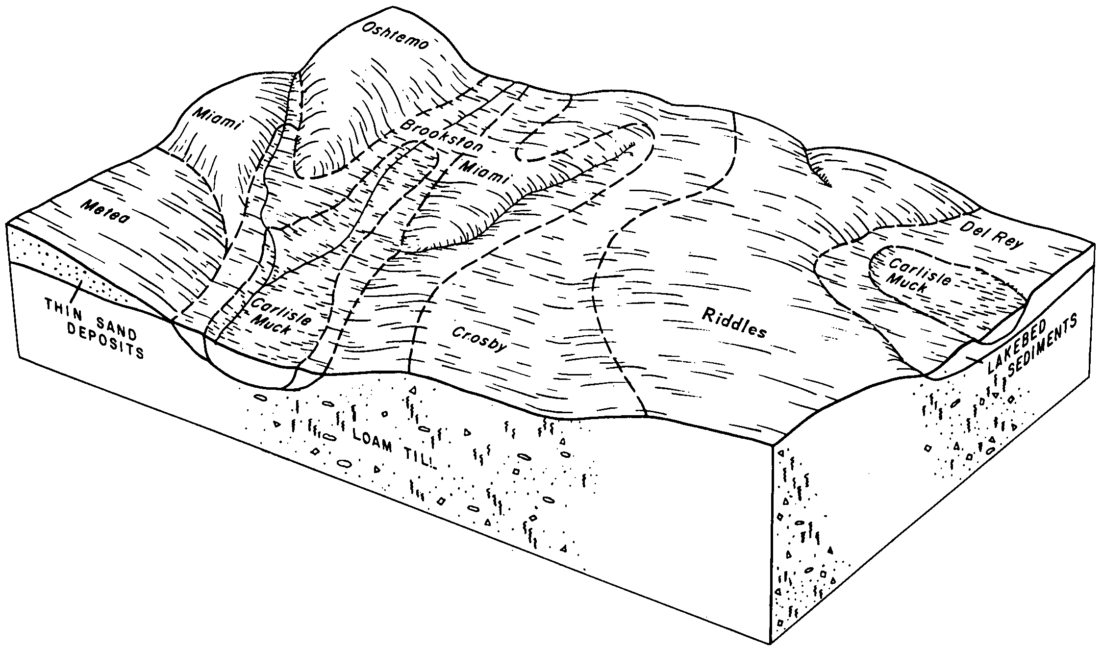
Del Rey, sandy substratum-Crosby silt loams, 0 to 2 percent slopes | DeA | 30 | 3291290 | 5fq5 | in057 | 1976 | 1:15840 |
Del Rey silt loam | De | 481 | 160862 | 5dd3 | in085 | 1985 | 1:20000 |
Del Rey silt loam | De | 1884 | 272452 | 94hs | in089 | 1967 | 1:15840 |
Del Rey silt loam, dark colored variant | Dl | 772 | 272453 | 94ht | in089 | 1967 | 1:15840 |
Del Rey, sandy substratum-Crosby silt loams, 0 to 2 percent slopes | DeA | 1 | 3291356 | 5fq5 | in095 | 1965 | 1:15840 |
Del Rey silt loam | De | 5278 | 160641 | 5d4z | in127 | 1978 | 1:15840 |
Del Rey silty clay loam, 0 to 1 percent slopes | DcrA | 1100 | 612324 | nk5d | in141 | 2001 | 1:12000 |
Urban land-Del Rey complex, 0 to 1 percent slopes | UfrA | 84 | 625293 | nznr | in141 | 2001 | 1:12000 |
Del Rey silt loam | Dr | 537 | 160196 | 5cpm | in151 | 1979 | 1:20000 |
Del Rey, sandy substratum-Crosby silt loams, 0 to 2 percent slopes | DeA | 54648 | 162135 | 5fq5 | in159 | 1985 | 1:15840 |
Del Rey-Blount silt loams, 0 to 1 percent slopes | DeA | 56638 | 161246 | 5dsh | in179 | 1988 | 1:15840 |
Blount-Del Rey silt loams, 1 to 4 percent slopes, eroded | BkB2 | 41201 | 161244 | 5dsf | in179 | 1988 | 1:15840 |
Blount-Del Rey-Urban land complex, 1 to 4 percent slopes, eroded | YbdB | 442 | 3216867 | 2yc35 | in179 | 1988 | 1:15840 |
Del Rey-Blount-Urban land complex, 0 to 1 percent slopes | YdbA | 435 | 3216868 | 2yc3c | in179 | 1988 | 1:15840 |
Urban land-Del Rey-Blount complex, 0 to 1 percent slopes | UdbA | 132 | 3216861 | 2z4fc | in179 | 1988 | 1:15840 |
Urban land-Blount-Del Rey complex, 1 to 4 percent slopes, eroded | UbdB2 | 124 | 3216860 | 2yc4l | in179 | 1988 | 1:15840 |
Del Rey silt loam, 0 to 2 percent slopes | DrA | 12647 | 186847 | 68fb | mi049 | 1967 | 1:20000 |
Del Rey silt loam, 2 to 6 percent slopes | DrB | 11235 | 186848 | 68fc | mi049 | 1967 | 1:20000 |
Del Rey sandy loam, 0 to 2 percent slopes | DlA | 489 | 186846 | 68f9 | mi049 | 1967 | 1:20000 |
Del Rey silt loam, 0 to 3 percent slopes | 62A | 791 | 188797 | 6bg7 | mi075 | 1979 | 1:15840 |
Del Rey silt loam, 0 to 2 percent slopes | DrA | 1891 | 192014 | 6ft0 | mi087 | 1966 | 1:15840 |
Del Rey silt loam, 2 to 6 percent slopes | DrB | 755 | 192015 | 6ft1 | mi087 | 1966 | 1:15840 |
Del Rey loam, 0 to 2 percent slopes | DlA | 4510 | 187634 | 697q | mi099 | 1967 | 1:20000 |
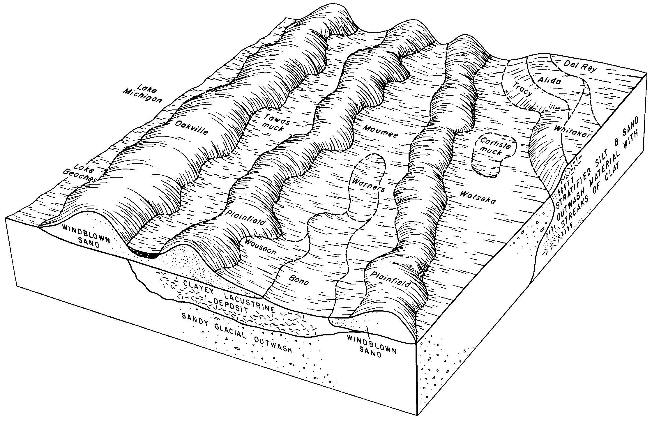
Del Rey-Metamora sandy loams, 0 to 2 percent slopes | DmA | 1972 | 187636 | 697s | mi099 | 1967 | 1:20000 |
Del Rey loam, 2 to 6 percent slopes | DlB | 624 | 187635 | 697r | mi099 | 1967 | 1:20000 |
Del Rey-Metamora sandy loams, 2 to 6 percent slopes | DmB | 238 | 187637 | 697t | mi099 | 1967 | 1:20000 |
Del Rey silty clay loam, 0 to 3 percent slopes | 2A | 1437 | 192539 | 6gby | mi105 | 1992 | 1:15840 |
Del Rey silt loam, 0 to 3 percent slopes | 14A | 10096 | 187224 | 68th | mi115 | 1980 | 1:15840 |
Del Rey loam, 0 to 4 percent slopes | 36B | 4429 | 186466 | 6811 | mi123 | 1990 | 1:15840 |
Del Rey loam, 0 to 2 percent slopes | 123A | 197 | 2508674 | 697q | mi125 | 1980 | 1:15840 |
Del Rey-Metamora sandy loams, 0 to 2 percent slopes | 127A | 22 | 2508678 | 697s | mi125 | 1980 | 1:15840 |
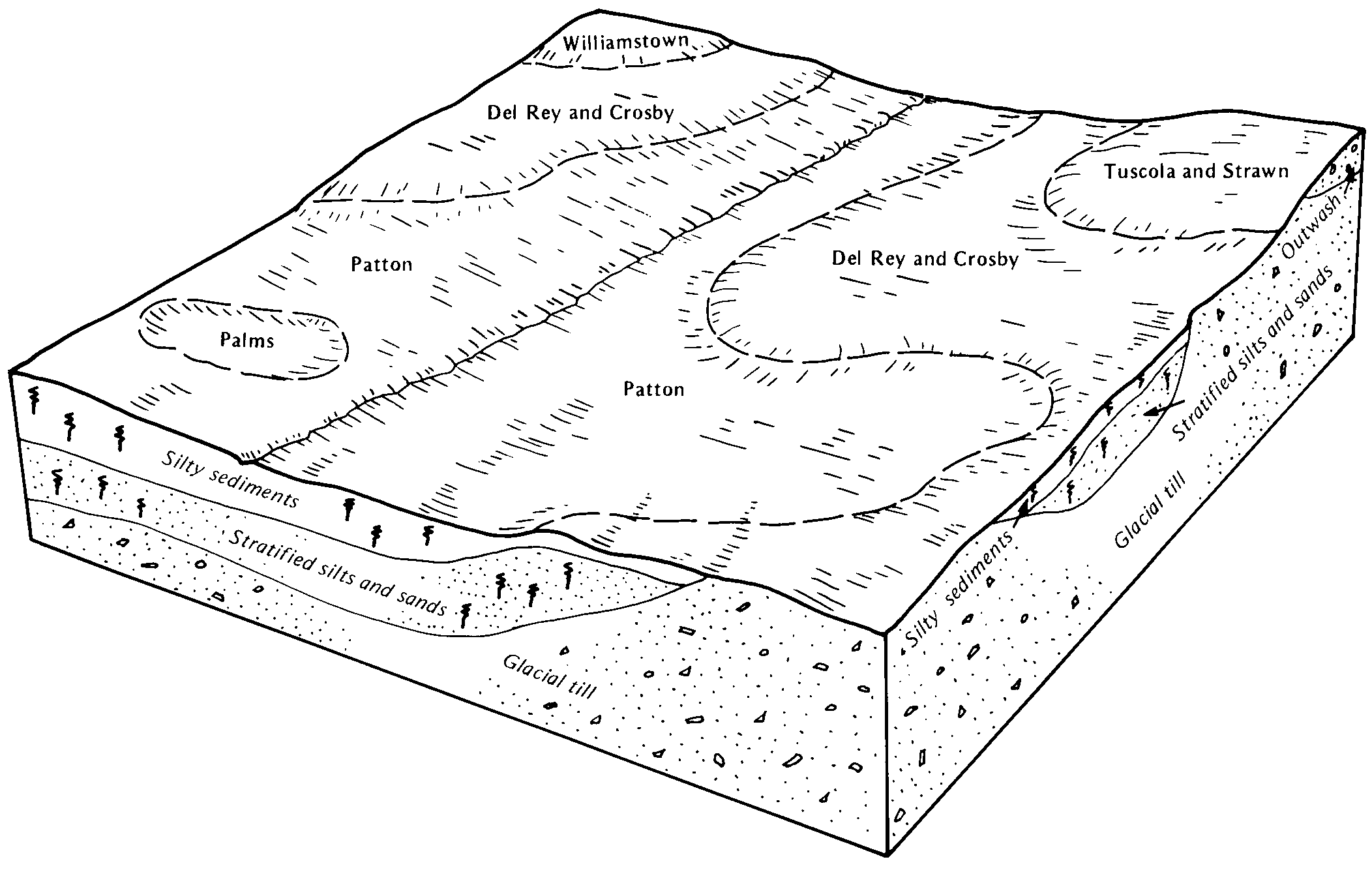
Arkona-Del Rey complex, 0 to 4 percent slopes | 27B | 2781 | 189009 | 6bp2 | mi127 | 1992 | 1:15840 |
Del Rey silt loam, 0 to 3 percent slopes | 36A | 405 | 189021 | 6bpg | mi127 | 1992 | 1:15840 |
Del Rey silt loam, 0 to 2 percent slopes | 108A | 126 | 2399404 | 2ljs4 | mi145 | 1991 | 1:15840 |
Del Rey silt loam, till substratum, 0 to 3 percent slopes | DeA | 3247 | 169677 | 5pkg | oh011 | 1979 | 1:15840 |
Del Rey, till substratum-Urban land complex, 0 to 3 percent slopes | DuA | 15 | 3216880 | 2ydd5 | oh011 | 1979 | 1:15840 |
Del Rey silt loam, 0 to 2 percent slopes | DdA | 3 | 1146233 | 17gr8 | oh011 | 1979 | 1:15840 |
Del Rey silt loam, 2 to 6 percent slopes | DeB | 1 | 1413809 | 1jg5r | oh021 | 1966 | 1:15840 |
Del Rey silt loam, 0 to 2 percent slopes | DeA | 776 | 168558 | 5ndc | oh033 | 1975 | 1:15840 |
Del Rey silt loam, 0 to 3 percent slopes | DeA | 212 | 168496 | 5nbc | oh037 | 1984 | 1:15840 |
Del Rey silt loam, 0 to 3 percent slopes | DfA | 3243 | 168438 | 5n8h | oh039 | 1981 | 1:15840 |
Del Rey silt loam, 0 to 2 percent slopes | DeA | 86 | 1539791 | 1np8p | oh039 | 1981 | 1:15840 |
Del Rey loam, 0 to 2 percent slopes | DdA | 1 | 1539790 | 1np8n | oh039 | 1981 | 1:15840 |
Del Rey silt loam, 0 to 2 percent slopes | DeA | 6551 | 172130 | 5s3l | oh043 | 1998 | 1:12000 |
Del Rey silt loam, 0 to 3 percent slopes | DfA | 4553 | 169076 | 5ny2 | oh051 | 1981 | 1:15840 |
Del Rey-Blount complex, 0 to 3 percent slopes | DfA | 6252 | 644383 | pmjk | oh063 | 1997 | 1:12000 |
Del Rey silt loam, 0 to 2 percent slopes | DeA | 179 | 644382 | pmjj | oh063 | 1997 | 1:12000 |
Del Rey silt loam, 0 to 3 percent slopes | DeA | 2043 | 168928 | 5ns9 | oh065 | 1987 | 1:15840 |
Del Rey silt loam, till substratum, 0 to 3 percent slopes | DfA | 2 | 1611219 | 1r2lt | oh065 | 1987 | 1:15840 |
Del Rey silt loam, 0 to 2 percent slopes | DfA | 701 | 168981 | 5nv0 | oh069 | 1968 | 1:15840 |
Del Rey loam, 0 to 2 percent slopes | DeA | 521 | 168980 | 5ntz | oh069 | 1968 | 1:15840 |
Del Rey silt loam, 0 to 2 percent slopes | DeA | 710 | 171106 | 5r1k | oh091 | 1977 | 1:15840 |
Del Rey silt loam, 2 to 6 percent slopes | DeB | 365 | 171107 | 5r1l | oh091 | 1977 | 1:15840 |
Del Rey silt loam, 1 to 4 percent slopes | DsB | 702 | 287752 | 9nfb | oh093 | 1972 | 1:15840 |
Del Rey-Urban land complex, 0 to 3 percent slopes | DcA | 4698 | 169831 | 5pqf | oh095 | 1978 | 1:15840 |
Del Rey loam, 0 to 3 percent slopes | DdA | 2468 | 169832 | 5pqg | oh095 | 1978 | 1:15840 |
Del Rey loam, sandy substratum, 0 to 2 percent slopes | DeA | 822 | 169833 | 5pqh | oh095 | 1978 | 1:15840 |
Del Rey silt loam, 0 to 3 percent slopes | DfA | 307 | 2510537 | 68th | oh095 | 1978 | 1:15840 |
Del Rey silt loam, 0 to 3 percent slopes | DeA | 5846 | 171187 | 5r45 | oh101 | 1984 | 1:15840 |
Del Rey silt loam, 0 to 2 percent slopes | DdA | 99 | 1400462 | 1j096 | oh101 | 1984 | 1:15840 |
Del Rey silt loam, 2 to 6 percent slopes | DdB | 6 | 1400463 | 1j097 | oh101 | 1984 | 1:15840 |
Del Rey silt loam, 0 to 3 percent slopes | DgA | 95 | 1412959 | 1jf9b | oh107 | 1975 | 1:15840 |
Del Rey silt loam, 1 to 3 percent slopes | DeA | 1427 | 170386 | 5q9b | oh123 | 1981 | 1:15840 |
Del Rey-Fulton silt loams, 1 to 6 percent slopes | DmB | 4699 | 170628 | 5qk4 | oh137 | 1971 | 1:20000 |
Kibbie-Del Rey silt loams, 1 to 6 percent slopes | KtB | 3345 | 170649 | 5qkt | oh137 | 1971 | 1:20000 |
Del Rey silt loam, 0 to 2 percent slopes | DlA | 3288 | 170626 | 5qk2 | oh137 | 1971 | 1:20000 |
Del Rey loam, 0 to 2 percent slopes | DgA | 1118 | 170625 | 5qk1 | oh137 | 1971 | 1:20000 |
Blount-Del Rey silt loams, 1 to 6 percent slopes | BrB | 343 | 170614 | 5qjp | oh137 | 1971 | 1:20000 |
Del Rey silt loam, 2 to 6 percent slopes | DlB | 267 | 170627 | 5qk3 | oh137 | 1971 | 1:20000 |
Del Rey-Blount complex, 0 to 3 percent slopes | DhA | 19 | 1529151 | 1nb6g | oh137 | 1971 | 1:20000 |
Del Rey silt loam, 0 to 2 percent slopes | DeA | 11630 | 169556 | 5pfk | oh143 | 1983 | 1:15840 |
Del Rey silt loam, 0 to 2 percent slopes | DeA | 2 | 1592210 | 1qftm | oh147 | 1978 | 1:15840 |
Del Rey silty clay loam, 0 to 2 percent slopes | DfA | 3581 | 168142 | 5myy | oh171 | 1975 | 1:15840 |
Del Rey loam, 0 to 2 percent slopes | DeA | 2401 | 168140 | 5myw | oh171 | 1975 | 1:15840 |
Del Rey silty clay loam, 2 to 6 percent slopes | DfB | 982 | 168143 | 5myz | oh171 | 1975 | 1:15840 |
Del Rey loam, 2 to 6 percent slopes | DeB | 865 | 168141 | 5myx | oh171 | 1975 | 1:15840 |
Del Rey silt loam, 0 to 3 percent slopes | DdA | 116 | 1414125 | 1jghy | oh171 | 1975 | 1:15840 |
Del Rey silt loam, 0 to 2 percent slopes | DeA | 9129 | 169605 | 5ph4 | oh175 | 1980 | 1:15840 |
Del Rey silt loam, 2 to 6 percent slopes | DeB | 2990 | 169606 | 5ph5 | oh175 | 1980 | 1:15840 |
Del Rey silt loam, 0 to 3 percent slopes | DfA | 11 | 1542646 | 1ns7s | oh175 | 1980 | 1:15840 |
Del Rey silt loam, 0 to 3 percent slopes | DfA | 728 | 753474 | t91m | wi025 | 1972 | 1:15840 |
Del Rey silt loam | Dc | 619 | 425217 | g8gp | wi045 | 1969 | 1:12000 |
Del Rey silt loam, 0 to 3 percent slopes | DcA | 3311 | 423778 | g6z8 | wi055 | 1976 | 1:15840 |

